
.png "English")


Hiking
Serifos has about 80 kilometers of paths, streets and dirt roads. These 80 kilometers cover the already-signed hiking trails of Serifos (A, 1-6), but also those which have not been signed yet (7-10).
These trails are all very impressive, each one with its own beauty, all together representing the original image of Serifos. They are also quite pleasant for someone to hike, since toward the one direction (the downhill) most routes are easy, walking on built paths that offer the chance of water supply.
Trails
Trail 1a: Livadi - Pano Chora

| Distance | : | 4.8 km |
| Trekking time | : | 2h |
| Level of difficulty | : | 1/5 |
The trail from Chora to Livadi, a crowded road in the older times, will be a trip to the past for many people. While walking through the alleys of Chora, if you have some imagination and love for this place, it will be easy for you to revive the deserted houses and their numerous stories. It will also be possible to listen to the whispers and voices from those houses, where people still reside. You will smell the delicious food that housewives cook, and you will be able to go up to the top for a moment, to the Castle, where you will feel as the master of the beautiful capital of Serifos. However, the view of the sea will call you to continue walking downwards to Livadi. In the road, you should pay attention to the details; names of the streets, small churches lying next to the white houses, the coat of arms and the signs such as that of the “Union for miners, workers at quarries and builders of Serifos”, the beautiful school building, the folklore museum but also two water springs. You will discover many things while walking. But be careful of the cars while crossing the road!
Trail 1: Chora - Kallitsos

| Distance | : | 4.4 km |
| Trekking time | : | 1.50h |
| Level of difficulty | : | 1/5 |
While approaching Serifos by ship, you might have seen a small village located in the mountains, at the barren eastern shores, shining from far away as well as from closer distance. It is Kallitsos, which you can reach from Chora by walking through a very beautiful path, full of surprises. At the slopes, which seem barren from far away, while walking through the stone-made paths, you will discover water springs, gardens, bridges and small churches. You will certainly meet a farmer coming home with his basket full of greens. You will listen to the reeds whispering while talking to the wind, or some of the Nereids which presumably live under the bridge of Kipoi. A little farther, the trail is quite ascending; it will lead you to Pano Stavros. You can take a breath there and enjoy the full view. At the next steps of the trail you will be impressed by the level of maintenance of the old cobbled street. And suddenly, at the highest point of the trail, at the gap of the hill Vounaki, you will turn, look at Kallitsos and start descending being carefree, having forgotten any fatigue caused by the upward slope. While entering the village and walking through its narrow alleys, you will understand why its name comes from the Greek word “kalliston” (the most beautiful).
Trail 2: Chora - Gyftika

| Distance | : | 2.1 km |
| Trekking time | : | 1.15h |
| Level of difficulty | : | 1/5 |
It might be one of the most spectacular routes of the Aegean. You walk in a cobbled street, quite steep (difficult during the summer), which was used in the past by miners. This trail could end through an alternative round track at the region of Gyftika.
Read More...
Trail 3: Akonidia - Koutalas
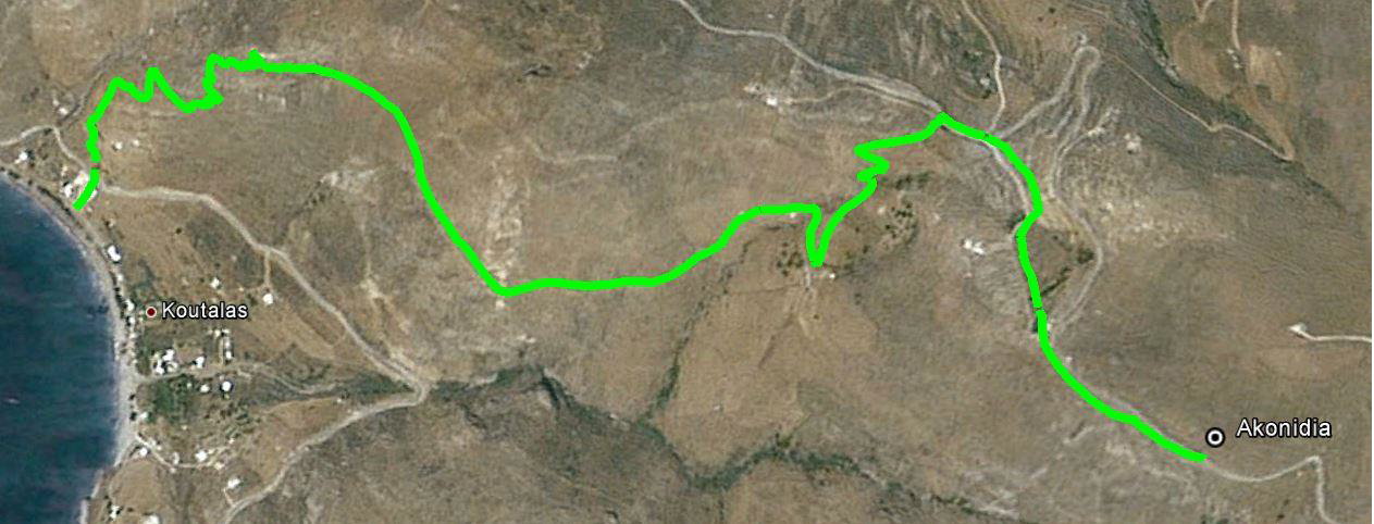
| Distance | : | 4.8 km |
| Trekking time | : | 2h |
| Level of difficulty | : | 1/5 |
Path number 3 comes down from Akonidia, the area where the impressive ancient “White Tower” is located, passes through old paths leading to the mines of the region, and ends in Koutalas beach. This trail gives somebody the opportunity to observe the way the whole process of mining and transportation of the minerals was made. Roadways, mining, rails for the mine-dumps as well as old, rusty descenders can still be seen. In Koutalas, visitor can also see the remains of the buildings of the old mining company.
Trail 4: Gyftika – Varsamos - Panagia

| Distance | : | 4.1 km |
| Trekking time | : | 1.40h |
| Level of difficulty | : | 1/5 |
The way the trail begins is somehow strange: from an old destroyed path which goes up to the higher slopes of Troulos, without showing its clear direction. Soon enough after the arrival at the highest part of the trail (over 500 meters high), the path is visible again, built and with a north-west direction. It consists of a big part of concrete road, which has to be quite exhausting while walking it up, especially during the summer. After this part of the road, the grade of the route becomes milder, and the path meets water springs and gardens as well as old sheep pens and churches. It reaches the picturesque village of Panagia, offering a great view to the east and the surrounding hills.
Trail 5: Panagia - Sykamia

| Distance | : | 3 km |
| Trekking time | : | 50m |
| Level of difficulty | : | 1/5 |
This route is a nice downhill (it is quite difficult for someone to ascend) from Panagia to beach Sykamia. In the beginning, it is quite descending while walking on a built path, but soon its grade becomes milder and goes along a beautiful creek, where there are old laundries, dovecotes and old watermills. It ends in a dirt road which leads to Sykamia. From Sykamia someone might use route number 6, which leads to Galani and is of milder grade.
Route 6: Pyrgos – Galani – Sykamia

| Distance | : | 3.8 km |
| Trekking time | : | 1.20h |
| Level of difficulty | : | 1/5 |
It is an astonishing route, which is of mild grade (also appropriate to ascend from Sykamia to Galani), with a nice view towards both directions and very impressive colors of the rocks and plants. The total trail is built, has got some shady areas ideal for relaxation and ends in Sykamia, where someone can refresh themselves in the waters of the beautiful beach. The part of the trail from Pyrgos to Galani passes through small gardens, crosses a pretty creek, and goes up to Galani through a path, which was probably built many centuries ago.
Route 7: Sykamia –Agia Thekla (Saint Thekla); this route has not been signed yet

| Distance | : | 6.8 km |
| Trekking time | : | 2.30h |
| Level of difficulty | : | 2/5 |
It is a beautiful route, which, in combination with the suggested route number 8, is a trip back in time. Through this route, a hiker visits ancient monuments, deserted settlements, hidden beaches accessible only by sea (and through this path, of course), and above all, walker remains far away from any signs of modern civilization. It is a demanding route for hiking, since it is a steep path on either direction. However, the sights and view reward generously those willing to walk it.
Route 8: Agia Thekla – Avessalos: this route has not been signed yet

| Distance | : | 2.9 km |
| Trekking time | : | 1.10h |
| Level of difficulty | : | 2/5 |
It is a very nice route, which we suggest that you follow downwards. While in the trail, you meet ancient sites (wall in Liomantra) as well as the beautiful deserted settlement Flomi. At this point, the route could alternatively be round passing through Notinos as well. Descending to Avessalos is somehow difficult, especially while at the last meters of the route. In addition, the carriage road leading to Avessalos is steep, and thus, it is difficult for means of transport to approach. It means that probably, hikers should continue ascending to the old settlement Telefti.
Route 9: Agios Panteleimon – Pente Pigadia – Livadi (suggested route)

| Distance | : | 3.6 km |
| Trekking time | : | 1,2h |
| Level of Difficulty | : | 1/5 |
This route has been erased from the time. It is a built path, which ascends with a quite mild grade from Livadi to Pente Pigadia. At some point it passes in front of the small church of St. Ioannis Theologos. At the region Pente Pigadia, it goes over small waterfalls and next to the church of Panagia (Virgin Mary). An old dirty road leads to Agios Panteleimonas from that point of the trail. This route could be combined with routes number 2 and A, so that hikers follow a one-day-long round course, or this route could become the first step of “The tour around Serifos on foot”.
Route 10: Kallitsos – Xero Chorio – Triantafyllos – Kallitsos (suggested route)

| Distance | : | 4.8 km |
| Trekking time | : | 2h |
| Level of difficulty | : | 1/5 |
It is a beautiful and relatively short circular route. It connects Kallitsos, where the fantastic mill (tavlomilos: a specific kind of mill) dating back to the 16th century is found, to Xero Chorio with its panoramic view, to the impressive winery Chrysoloras, to the old settlement of Triantafyllos and to the oak forest of Voudomantra. In this area, there are many ancient remains, but you need a trained eye to spot them. It is ideal for an afternoon walk.
Take a look at the overall Hiking Map on the island of Serifos
